
Every couple of years I try to make it over to Grand Staircase Escalante National Monument and do some new exploring. Last summer was one of those years and this time I took Kona and Maree. We stayed in Escalante for three nights and one of the days we did a road trip over Boulder Mountain to Capitol Reef and then back along the Burr Trail. The loop went faster than I expected so we made an additional detour up Hell’s Backbone Road. I had not been up there in 18 years so my memory was foggy.
In terms of inaccurate memories the portion of the road from Boulder to Capitol Reef went much faster than I remembered while Hell’s Backbone took more than twice as long as I remember. The road was the original route between Boulder and Escalante until they blasted Scenic Byway 12 through the slickrock wilderness that is now the national monument. There’s a road sign along Byway 12 that says one of the biggest reasons for the massive engineering project was, get this, to help a few farmers get their custard to the metropolis of Escalante without the custard spoiling.

Just throwing this in because I can’t remember ever seeing a 5 way dirt road intersection. We took an old forest road from Widtsoe Junction, which is i kind of ghost town. Forest Road 17 was the original road to Escalante and follows the headwaters of the Escalante River down the “main canyon” into town. It was a nice change of scenery.

We took a break from the drive and walked way up a side road that ended in meadows on top of the Escalante Mountains. The trail eventually brought us to an expansive view both to the east and west from 9,600 feet. This is looking West at the Sevier Plateau but it was cool to look East and see the Henry Mountains from what was basically as far West as Kodachrome Basin.

Just outside the town of Escalante is Escalante State Park. The park has a reservoir, a campground and a petrified forest.


A close up of the bark on a petrified log and the other picture shows the growth rings of a larger log that looks chopped down by a prehistoric lizard lumberjack. It’s illegal to collect the petrified wood, and it’s important to remember that most petrified wood in Utah is radioactive.

Kona explores the Aquarius Plateau.

I don’t remember ever seeing this large hidden valley at the base of Boulder Mountain. There also was a large reservoir near the valley. I think it’s called Pleasant Creek Valley. Mt. Ellen looms in the background.

A nice Aspen grove on Boulder Mountain.
Because we were driving around with Kona we didn’t do anything in Capitol Reef, where dogs are not allowed. It was pretty busy there anyway, so we hurried on to the less crowded Notom-Bullfrog Road. Somehow, although I’ve driven the Burr Trail many times over I had never approached it from the North. The road is partially paved now. I don’t remember if it used to be that way but the whole section until the switchbacks went much faster than I anticipated. At the switchbacks I was shocked to encounter traffic for the first time ever. There were several other vehicles I had to deal with.

We left the high ground and entered the hot desert on Notom Road.

Some great sediments along Notom Road.

Lavender!

One of those pictures I like to take where everyone is doing something weird but it works compositionally.

Looking South along the Waterpocket Fold.

Looking North along the Waterpocket Fold. So many cool possibilities along that wall.


We stopped for a break along the Burr Trail and walked down a short and popular side canyon.


The infamous narrow bridge crosses a natural gap in the spine of rock.

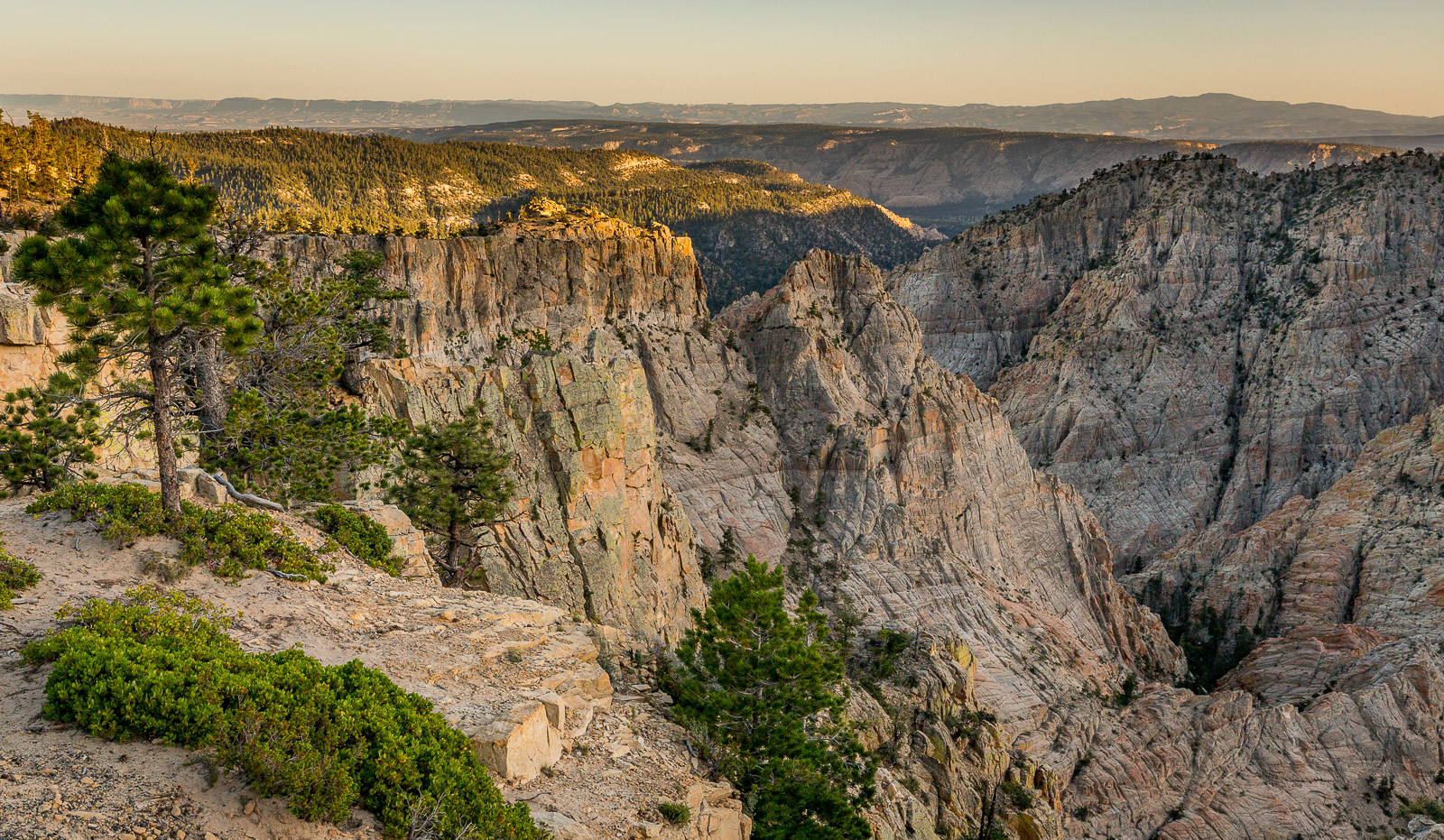
Looking down from Hell’s Backbone into the canyon below the scary bridge.

One of the things I did not remember about Hell’s Backbone Road was the interesting canyons on the East side of the bridge. Back then I probably considered them unreachable but that is not the case.

Another interesting looking canyon off the east side.

Maree tried to summon the courage to walk out to the edge.

They say the fall from the bridge is 1,500 feet on both sides but it’s not a straight drop. It’s still a scary road with some areas that have a lot of exposure.

Hell’s Backbone Road eventually spits you out on the West side of the massive folding that created Capitol Reef and I suppose the San Rafael Swell.