Red Mountain Traverse, Utah
Categories: Hiking
Red Mountain Traverse is an extremely strenuous expert only backcountry hiking route (not a trail) that offers tremendous views of Snow Canyon State Park and passes through an amazing variety of landscapes. The hike is 10 – 12 miles depending on how you choose to do to it and any side trips you might do. It’s a one way hike but to make it a loop I decided to do a hike and bike, which made my trip a total of 22 miles. This hike is in Southern Utah and not to be confused with another Red Mountain Traverse located in Wyoming. A map and description of the route is here.
Red Mountain looms above Ivins, Utah and is part of the Red Cliffs National Conservation area which includes the Red Mountain Wilderness. There is usually no water on the route, temperatures are extreme in warmer months, weather is unpredictable on the top of the mountain and there are no markings on the route. Research and preparation beforehand is absolutely necessary. Red Mountain is notorious for rescues off the mountain. Because of this I decided to do the route in reverse, going up from the bottom and generally continuing uphill to the other end of trail. The last couple of miles is on an old jeep trail, and since I didn’t know how long it would take me, I thought it would be nice not to have to climb down the mountain in the dark, when I was tired. Both of the “official” routes off Red Mountain are confusing and difficult to find. I also wanted to use this hike to get in shape for some harder things I wanted to try later.

Red Mountain looms over Ivins. It looks pretty intimidating and it’s not easy but there’s a way up through those bands of cliffs over on the sunny side.


One of the unique and cool things about the traverse is that you start or end the hike right at the end of a street in an Ivins neighborhood! There are very few epic hikes that end that way. It reminds me of the spectacular Carthew Alderson Trail in Canada’s Waterton Park or the amazing Walrus Lakes hike in Anchorage, Alaska. On the right side picture the trail starts on the ridge in the foreground.

The trail up Red Mountain is a brutal 1,500 foot climb in about 1 mile. For comparison, Angels Landing in Zion is 1,500 feet in 2.4 miles and that trail is famously steep.

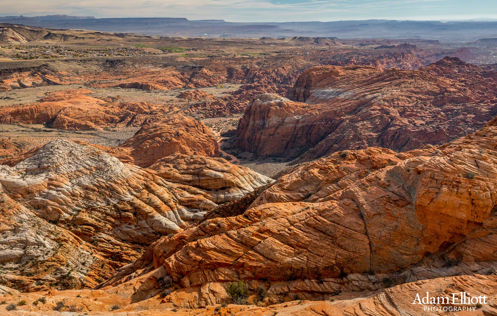
Near the top looking down at Ivins.

Although it’s about 60 feet beneath the summit I count this monolith as the end of the hard stuff and I’m always happy to get here. It’s really the first time you’ll experience anything approaching “level”.

Behind the monolith you’ll be delighted to travel up this bouldery hallway. It’s a nice change from the rugged scramble up the mountain, and it might even be shady. Enjoy that shade because it’s the last time you will.

Looking at the Beaver Dam Mountains from the summit of Red Mountain. This took place in late November.

Once you’ve made it to the top of Red Mountain you can pat yourself on the back because you made it to… the beginning! This panoramic view does not look like what one expects to see at the top of a mountain. The Red Mountain Wilderness stretches out before you. It’s all sand. You have to hike down a few hundred feet before you can work your way up the far end of the valley.

Looking down into the Rocky Bowl. On subsequent trips I explored around down there and beyond the opposite side. It’s pretty neat.

The back of the bowl is a nice barren slope.

Looking back at the last good view of the Beaver Dams.


Congratulations you made it to…. yet another rugged desert valley. At this point it should really be sinking in what kind of task you’ve chosen, and this would be a good place to turn around if you aren’t feeling up to it. The correct route can be confusing between this area and the last, so really pay attention to landmarks and maps. It’s like trying to navigate between turbulent ocean waves of rock. This was also the hottest of all the valleys I walked through. After the valleys the land opens up into a miles long dune field. Instead of walking through this stuff I decided to heads east towards Snow Canyon State Park.

Once I arrived above this surprise, hidden canyon I noticed I had been taking pictures all day at ISO 1600, in bright sunlight. That was a really stupid thing to be doing and explained why everything was looking so contrasty. I think the previous evening I had been taking some after sunset shots or something, and forgot to reset the ISO.

The very beginning of a deeply incised canyon. As steep as it was it looked like I could get down here if I needed to.

A little bit farther and you will see some white sandstone caps on top of the orange rock.

Looking back again. The top of Red Mountain is well over a mile beyond those most distant peaks. It’s a dry place. The animal tracks I found in these dry pools looked desperate.

This looked like a good place to return for spring flowers.

After a mile of walking across open orange slick rock there white slick rock begins to replace it.

A great view looking down another hidden canyon.

Leaving the walk along the rim of Snow Canyon and entering the West Canyon area.

Eventually the flat areas get pinched off and it’s necessary to traverse a small area of sand dunes again. These dunes are taller than the previous ones and made out of the white rock sand.

The reward of making through the last section of dunes is an even more wide open area of barren rock travel for almost another mile.

This is really a great place and reminded me of the wide open areas near Escalante.

This was one of the largest water pockets, so big it had a grassy meadow in it.

There’s a lot of up and down in the white rock section but it’s fun hiking.

The deepest hole. This was about 30 feet down and must be a real oasis during wet months.

A strange scene.


Eventually you will arrive at the old jeep/cattle trail. It’s incredibly rocky and I find it very boring. There are several large hills the road will take you over before connecting to the Snow Canyon Overlook trail.

One last view of West Canyon before the trail heads away from the rim.


At the end of the trail I had my bike waiting for me. The foot hike had been 10.5 miles. From there it was an 11 mile mostly downhill ride back to Ivins.