A few miles from the continental divide high up in a glaciated hanging valley in the Teton Wilderness, is a mysterious limestone cave at almost 10,000 feet. The cave was discovered long ago in 1889, but to this day has never been fully explored. The largest expedition to the cave was in 1971 but after that it was largely forgotten and wasn’t easy to find. Additionally, there is a room in the cave with a 40 foot ceiling but I could not find a single picture inside the cave other than looking out the entrance. So I decided to go there.

I was originally going to hike here on a trail called “The Pinnacles,” if i remember correctly. Unfortunately the trail was closed after a few miles due to a landslide.

It had been raining most of the night so it was humid and in places very muddy in the valley bottom. In fact i was worried it was going to rain some more, but after an hour the weather became fantastic and I found myself walking through miles of wildflowers.

Seriously, the flowers were ridiculous!

My first view of the Breccia Cliffs. I was hoping to possibly get up there if I found a way.

On top of an anticline ridge at 10,000 feet that separates several basins. In the distance you can see the Grand Tetons. There were stellar views in all directions from this ridge.

After the high ridge the trail descends into a karst valley and, after crossing it, climbs into wooded slopes interspersed with flat bottomed shallow tarns.

Shortly after the lakes the trail comes out of the woods into this small, strange shallow valley. It turns out the whole place is a an ancient sinkhole. Several tiny streams converge here.

The entrance to Holmes Cave lies at 9,600 feet. I’ve seen streams this calm exiting a cave but never entering one.

The entrance was smaller than I’d hoped. There was no choice but to get wet on the way in there. It was starting to rain anyway, you can see the drops in the stream.


Inside Holmes Cave. Not great but it’s hard to take cave pictures with a 4lb camera in one hand, a flashlight in the other,and with your feet wedged on either side of a freezing cold creek so you don’t fall down the pit you’re leaning over. The second picture is a wide angle view so those rocks in the bottom are stretched out and much closer to my feet than they look. You cannot stand there, it’s a cliff. The falls is about 12 high, then it takes a 90 degree right turn, flows about 8 feet and goes off a similar falls while turning 90 degrees the other direction. It’s quite a bit different than the old map and report I had looked at, which made it sound like this part was an easy climb down a huge log and smaller terraces. Oh well, I never seriously considered that I’d be able to make it far.

Once i climbed back up to the meadows I decided to do some more exploring. Not being able to go far into the cave granted me a lot more above ground time. This is on top of a neat little mini-glacial moraine that I crossed while heading to those cliffs on the far right.

The long exposed ridge ahead was very tempting but at this point I was worried about lightning. There was thunder rolling by now and then and it had already rained once.

Looking north into more of the Teton Wilderness. Less than 22 miles in a straight line to Yellowstone National park, and no roads.
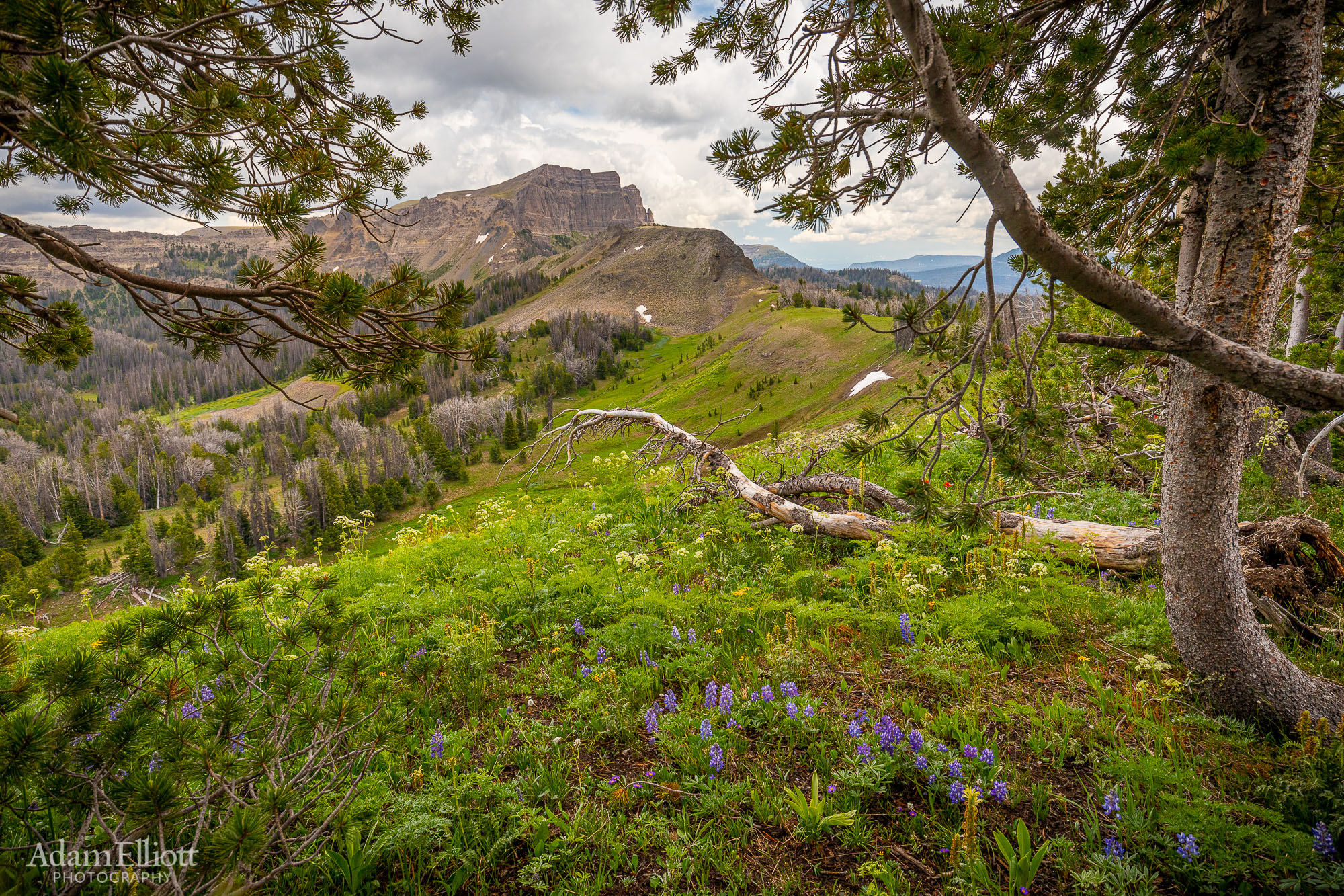
I headed back where I came and started my main side goal. Walking the rim of this high glacial cirque towards the distant cliffs.
The other reason I wanted to see Holmes Cave was that I’ve never been in a real cave at such a high altitude. What struck me when I had gone inside was it smelled exactly the same as caves back in Alabama. And once I was in the high basins I started seeing familiar karst landscapes all over the place, laid on top of old glaciated landscapes. That was a new, unique combination that I really enjoyed.

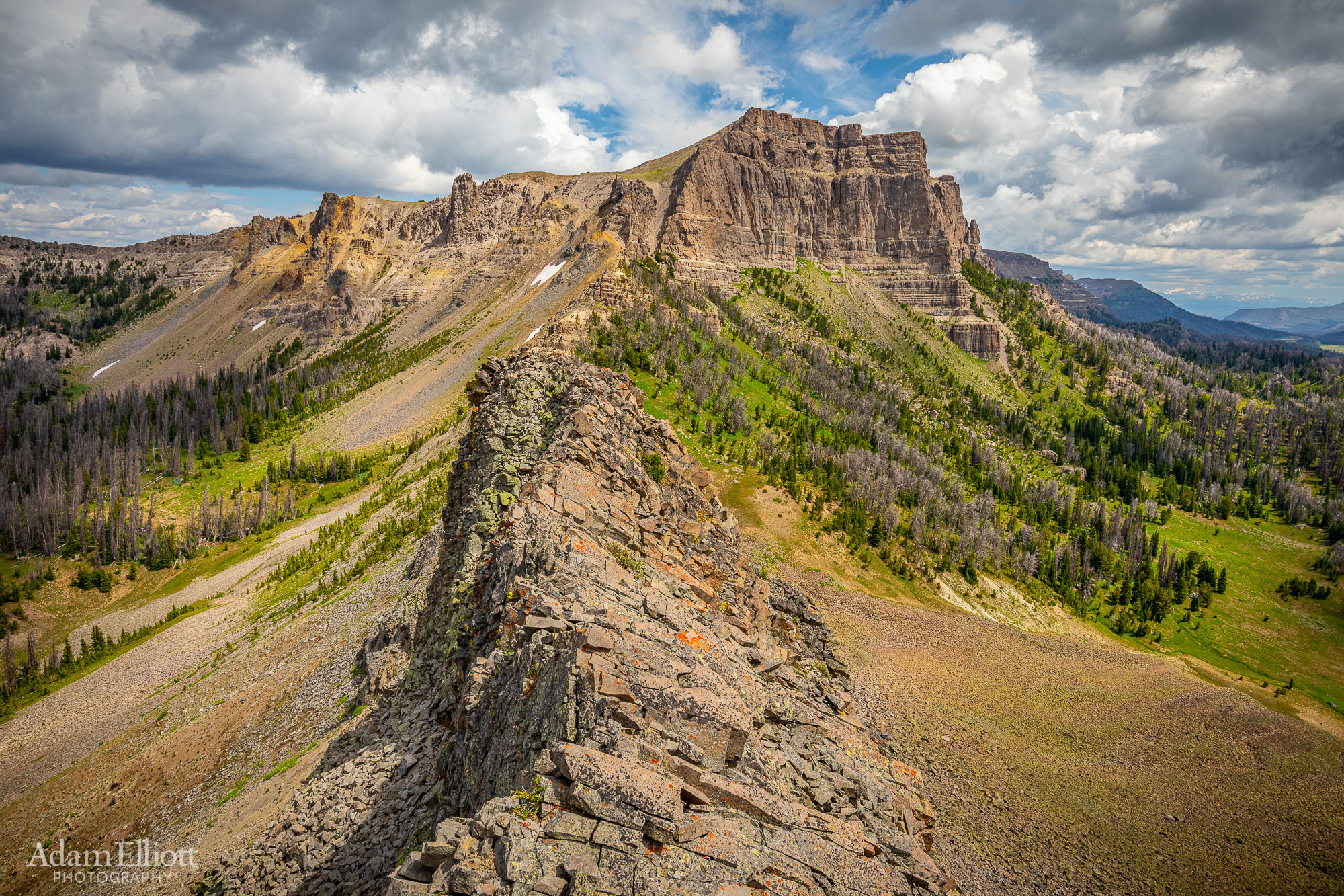
This was fun. The stone “hill” left of center was a bit of a pain, being made of a jumble of large unstable lava boulders, and the other side was a very steep climb back up to the ridgecrest, but after that it was great.
I think I’m standing on a lava dike 3 or 4 feet wide. The ridge continues to the Breccia Cliffs. The actual peak is another two miles. This was about 10,400 feet and I was getting tired from scrambling around at this altitude all day. And the weather was slowly storing more energy, so no more climbing.

Lookine SE at the Continental Divide. That prominent mountain on the right is called Two Oceans Mountain. The peak is on the Western side of the divide but the left shoulder is on the East side. Pretty weird perspective but the divide comes straight down the left face of that mountain. Just behind the long wooded ridge coming off the left side of Two Oceans is the origin of the Wind River. If you follow that ridge a little more left past the yellow meadow you will see a little bit of the highway as it crosses over the divide. Also of interest, in the foreground on the right is a large, deep sinkhole in a forest clearing. So strange to be in a karst landscape this high up.

I didn’t want to walk back across the lava boulders so I decided I would go straight down here and make my way cross country. I knew the highway was at the bottom of the valley where the forest meets the shaded meadows in the distance.

A panoramic view of this massive limestone syncline. The summit ridge stretching for miles off into the distance is called Angle Mountain.

Off the rocks. After this it was incredibly easy walking the rest of the way back.

I had no problem at all eventually spotting the trail and connecting back to it.

Several more miles of flowers to end the day, this time downhill.

I saw another trail over there on those slopes. I have no idea where it goes.

I made it back to car just as it was really starting to rain.

Back at the Hatchet Resort, where the only thing worth buying on the menu is hamburgers.