Last winter, during the longest cold snap in Utah, I decided to head to Yuma, Arizona, to check out several areas in the region I had never seen. The closest I’d been until then had been the Salton Sea to the West, and Phoenix to the East, a pretty large gap in my knowledge of the southwest. I decided to take different highways on my way down and back, to see as much as I could on the trip.
Of the places I decided to visit, climbing Signal Peak was the most daunting, and most logistically inconvenient, so I decided to do that first, before anything bad happened. Signal Peak is the highest of the Kofa Mountains, with a summit at 4,877ft., not a high summit by my standards. But, the valley floor quickly descends to less than 500 feet to the south, and the Sea of Cortez is only 115 miles away, so the views are stunning. There are some smaller mountains in that direction blocking the view and it was a hazy day when I was there, but on a clear day I wonder if you can see the ocean.
The mountain is in the Kofa National Wildlife Refuge. The name Kofa sounded exotic, until I learned it was an abbreviation for King of Arizona Mine. The gold mine, in King Valley, used to stamp it’s property K of A. The mine was very profitable.
I was happy that, despite tons of ATV and van life traffic, I was alone the entire day except for meeting one couple on the way up. We both startled each other, one of those situations where you somehow can’t see or hear people until you walk right into each other around a corner.

Signal Peak is a strange jumble of cliffs and blocks. This is the west face but the usual route up is from a valley on the north face.

The start of the trailhead is easy to miss, as it’s behind some bushes from the main stream bed in Queen of Kofa Canyon, which you drive up to get there. 4WD highly recommended.

I didn’t have a GPS route (I typically don’t), so I was really wondering how the trail was going to get up the cliffs, or if i’d be heading towards a yet unseen canyon.

My question about the route was soon answered as the trail starts climbing steeply.

Kofa is in the Sonoran Desert (at least the bottom of it is), so there were a lot of these Teddy Bear Cholla to keep me company. They will help break your fall if you slip.

This section was the most rugged and steep, both on the way up and down.

After the very steep section I arrived at a narrow pass with a bit of flat space where I was able to take a break.
It’s a bit of a long drive from Yuma. Traffic is very slow for the road and with dirt road travel it takes 2.5 hours to get to the trailhead. It turned out the cold front I was running from extended all the way into Mexico, so I only experienced moderately warmer temperatures, and also dealt with continuous high winds for much of the trip, and the day I decided to climb Signal Peak was the coldest of the trip. High winds and lots of cold shadows, but the sun was warm, so it was difficult to dress, basically a lot of changing layers throughout the day. The trail itself is surprisingly good and there were only a couple of spots, mostly in open rock areas, where there was any question about which way to travel.

From the pass you are treated to entirely new scenery, and a short stretch of horizontal travel.

Looking up at cool rhyolite cliffs.

These frozen, wind blown water ripples confirmed my suspicions that it was indeed very windy and cold.

Breaking out of the shadowy north face canyons onto the sunny upper slopes felt very good.

Ten Ewe Mountain rises monolithically from the top of the range.

The spectacular summit view from Signal Peak.
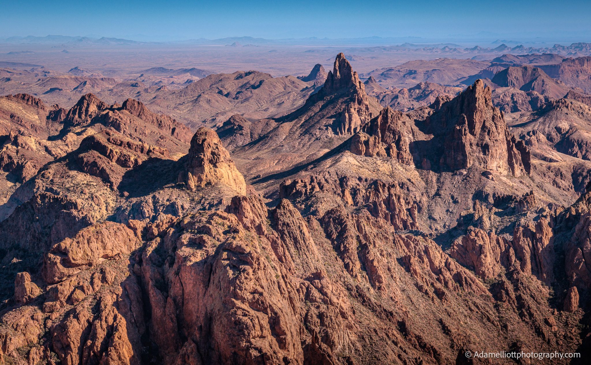
Wild towers tilt off kilter, riding the crest of the Kofa Mountain Range to the east.
The trail climbs relentlessly, at times a bit rugged and definitely hard on the knees coming back down. The top of the mountain is large and complicated, with a lot of room to explore rocky offshoots. The views on the top exceeded my expectations. To the west, the direction of the highway and all the campers, you can peer off into the restricted Yuma Proving Grounds. To the north was probably the least interesting view, being endless and anonymous mountain ridge lines but with some notable peaks worth looking up on the far horizon. To the east the view was by far the best, with exotic and inspiring pinnacles and peaks streaming off into the distance down the backbone of the mountain range.


The view to the south was the most surprising to me, partly because I’d never seen pictures of it. A vast and barren alluvial plain devoid of any sign of roads or structures, the look of true wilderness. It extended off into the distance for 40 miles and had incredible water collecting potential for flash floods. The southern edge of the plain was contained by a low lying but very interestingly shaped mountain ridge line. From the top, it looked like there were empty areas between fractal, dendritic patterns of vegetation. A few days later, driving in another area, I confirmed that. Like Death Valley, there is a lot of completely barren areas of ground.

More pinnacles and detached cliffs to the northwest.


Large primitive shapes. I don’t know what’s up with the large circular hole in the background.

The view to the west allows you to see far into the Yuma Proving Grounds, the Army’s premier test center. It features the longest overland artillery range in the nation, and they say you can find unexplored ordinance on Signal Peak.

Another weird feature is a yellow layer of rhyolite that permeates the mountain. Here Ten Ewe Mountain appears as a completely different shape, with a round ball of yellow pinching into a thin arc that wraps under the rest of the summit.

There’s also a massive cliff beneath the summit block of Ten Ewe.

I think this is Summit Peak. I’ve heard conflicting accounts as to whether it is a technical climb or not. There might be a deadly non technical route.


Time to head back down.
I had intended on staying up on the peak until late in the day, close to sunset, to get photos of the fantastic pillars to the east. But no matter where I went, I could not find adequate protection from the wind that day. And even plastering myself up agains dark brown walls of rock, the sun was unable to do it’s job and keep me warm. Despite wearing all my clothes I was slowly getting colder. Eventually I noticed my drinking water was close to freezing. So, reluctantly, I headed back down.
Once back to my car, because I’d left the summit more than an hour early, I had time to explore some of the formations in Queen of Kofa Canyon. It’s full of amazing rhyolite towers, fins and arches.

Queen of Kofa Canyon is spectacular at sunset.


On the left is an arch, on the right a false arch, and the lower right is a recent rockfall.

Early in the day this tall pillar stuck out, but coming back in the evening I noticed some light coming through the bottom of it.


I stopped to take a look and sure enough, there’s a wide arch in the bottom of it. You can almost stand up straight underneath it (in one particular spot), and there is a pile of rocks at the base to help you get up into it. I looked it up and it’s called “The Mail Slot”.

The last bit of QoK Canyon breaks into a thin chain of rock towers… and then it ends.

An ocean of cholla at sunset was a nice treat for the end of the day.